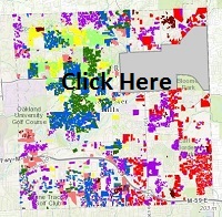
This exhibit incrementally displays the development of Avon Township (Rochester Hills) through marking construction plots (in colors by era on the map) during our community's history.
Please remember while viewing this exhibit that the grey lines on the map show current roads. Major roads, such as M-59, were not constructed at the time of the early settlers: this means that many plots may have been built, torn down, and then built again multiple times. Most likely, if the map had been created in 1820, the grey lines would have followed river beds and hills. Physical geography was much more important to our early settlers in guiding construction methods and limiting development locations than it is now.
Rivers were a prime power source as water powered mills were constructed throughout the 1800s, eventually serving industries from paper to sugar [beets] to grist to wool. Today we can visit Yates Cider Mill as an excellent representation of the period.
Eventually railroads replaced rivers for transportation by providing efficient and fast transport for both freight and passengers. Rochester and Rochester Hills at one point had the Michigan Central Rail Road, the Grand Trunk Railway, and the Detroit Urban Railway. These railroads served as the precursor to the interstate road system built in the 1950s. Both the Paint Creek Trail and the Clinton River Trail is are built on former railroad beds.
The freeways that we see now, namely M-59, provide the next evolution of transportation, uniquely serving our community because it directly connects our community's roads. On the map we see M-59 and how the built environment increased around it.
This map represents the built progression of Rochester Hills and can provide a geographical understanding of the City's evolution from individual farms to a suburban community.